Description
Unmanned aerial vehicles (UAV) are used primarily used in surveillance and control of maritime traffic, construction surveillance, detection and control of coastal hazards, flood monitoring, terrain mapping, fire disasters, remote data acquisition of existing pavement conditions, earthquake damage assessment, and post distress monitoring survey. UAV’s come with high-quality cameras and a global navigation satellite system – making it possible to collect survey-grade data and develop 3D models which can be used be to access pavement distress, rock-cut stability assessment, stockpile volume determination.
Specifications
Operating Temperature: 14° to 104° F ( 0° to 40° C )
Gimbal Stabilization: 3-axis (pitch, roll, yaw)
App/Live View Latency: 220ms (depending on conditions and mobile device)
Sensor: 1/2.3” Effective pixels:12.4 M
Lens FOV: 94° 20 mm (35 mm format equivalent) f/2.8, focus at ∞
ISO Range: 100-3200 (video) 100-1600 (photo)
Hover Accuracy: Vertical: +/- 0.1 m (when Vision Positioning is active) or +/-0.5 m Horizontal: +/- 0.3 m (when Vision Positioning is active) or +/-1.5 m
Shutter Speed: 8s -1/8000s
Image Max Size :4000×3000
Still Photography Modes: Single shot Burst shooting: 3 / 5 / 7 frames Auto Exposure Bracketing ( AEB ): 3 / 5 bracketed frames at 0.7 EV Bias Time-lapse HDR
Video Recording Modes: UHD: 4096×2160 (4K) 24 / 25p 3840×2160 (4K) 24 / 25 / 30p 2704×1520 (2.7K) 24 / 25 / 30p FHD: 1920×1080 24 / 25 / 30 / 48 / 50 / 60 / 120p HD: 1280×720 24 / 25 / 30 / 48 / 50 / 60p
Flight time: 30 minutes
Weight – 1.38kg
Applications
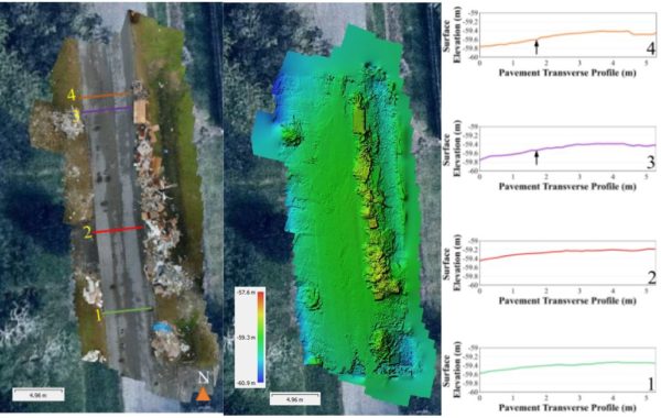
Pavement Crossection using UAV-CRP – identify abrupt changes in the elevation of the pavement.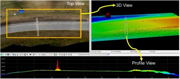
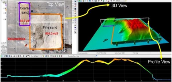
Two stockpiles surveyed at a flight altitude of 22.9 m (75 ft) above ground level (AGL) using UAV-CRP technology.
Publications
- Congress, Surya Sarat Chandra, Anand J. Puppala, Aritra Banerjee, and Ujwalkumar D. Patil. “Identifying hazardous obstructions within an intersection using unmanned aerial data analysis.” International Journal of Transportation Science and Technology (2020).
- Puppala, Anand J., Surya SC Congress, Nagasreenivasu Talluri, and Ekarin Wattanasanthicharoen. “Sulfate-heaving studies on chemically treated sulfate-rich geomaterials.” Journal of Materials in Civil Engineering 31, no. 6 (2019): 04019076.
- Congress, Surya Sarat Chandra, and Anand Jagadeesh Puppala. “Evaluation of UAV–CRP data for monitoring transportation infrastructure constructed over expansive soils.” Indian Geotechnical Journal (2019): 1-13.
- Puppala, Anand J., and Surya Sarat Chandra Congress. “A Holistic Approach for Visualization of Transportation Infrastructure Assets Using UAV-CRP Technology.” In International Conference on Information technology in Geo-Engineering, pp. 3-17. Springer, Cham, 2019.
- Congress, Surya SC, Anand J. Puppala, and Cody L. Lundberg. “Total system error analysis of UAV-CRP technology for monitoring transportation infrastructure assets.” Engineering Geology 247 (2018): 104-116.
- Puppala, Anand J., Surya SC Congress, Tejo V. Bheemasetti, and Santiago Caballero. “Geotechnical data visualization and modeling of civil infrastructure projects.” In GeoShanghai International Conference, pp. 1-12. Springer, Singapore, 2018.
- Puppala, Anand J., Surya SC Congress, Tejo V. Bheemasetti, and Santiago R. Caballero. “Visualization of civil infrastructure emphasizing geomaterial characterization and performance.” Journal of Materials in Civil Engineering 30, no. 10 (2018): 04018236.